 |
| Payette Lake image via Wikipedia |
Thursday, April 7, 2011
McCall
The coolest thing I did during spring break was go to McCall. While the rest of my family except for my mom and sisters skied, stayed at the condo and took a nap. While this sounds rest full for some, it was boring. But that aside, McCall was beautiful. It got tons of snow while we were there. That was what I did on spring break.

Friday, March 25, 2011
Intrests in North America
There were several countries interested in North America. The first of these was Spain. Spain had three main reasons to explore North America. According to Washington: A State of Contrasts, a book by Dale Lambert, the first thing was they wanted the western entrance to the northwest passage. With the northwest passage explored, they wold be able to have much faster trade in the northern hemisphere. Their second interest was control of the Native Americans. Their final interest was gold and silver, according to Washington: A State of Contrasts by Dale Lambert.
The next country interested in North America was Great Britain. They wanted only one main thing, and that was the northwest passage. If they could find it, it would give their navy a foothold in the area, and from there they could safely trade without Spain attacking them.
The next country interested was Russia. According to Washington: A State of Contrasts, a book by Dale Lambert, Russians were interested in discovering the Bering Straight, claiming Alaska,establishing trapping and trading posts, and exploring islands north of the Queen Charlotte Islands.
The last country to explore this area was the U.S. The U.S. was interested in establishing a claim in the area. They did this through the Lewis and Clark expedition, and Captain Robert Grays expedition.
The next country interested in North America was Great Britain. They wanted only one main thing, and that was the northwest passage. If they could find it, it would give their navy a foothold in the area, and from there they could safely trade without Spain attacking them.
The next country interested was Russia. According to Washington: A State of Contrasts, a book by Dale Lambert, Russians were interested in discovering the Bering Straight, claiming Alaska,establishing trapping and trading posts, and exploring islands north of the Queen Charlotte Islands.
 | |
| William Clark picture via Wikipedia |
Tuesday, March 15, 2011
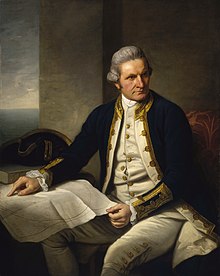
James Cook
 |
| Image via Wikipedia |
natives on the same voyage as he did all of these things.
 |
| Image via Wikipedia |
Friday, March 4, 2011
The Three Most Plausible Indian Migration Theorys
The first plausible theory about how indians migrated to North America is the land bridge theory. This states that during the ice age there was much less water in the ocean and more in the form of ice on land. Because of this, according to the book Washington: A State of Contrasts, there was dry land in the Bearing Strait. Also the book states that the Indians could walk across the land. They would have a sort of land bridge .
The next theory is the ice bridge theory. This states that the Bearing Strait could have just froze. This is also stated as a possibility in Washington: A State of Contrasts. The book then states that if it was frozen, the Bering Strait would still be able to be walked across.
The last plausible theory is that when the water was lower in the ocean, which according to Washington: A State of Contrasts it was, that a narrow shelf was exposed. This shelf, and this theory are both named the continental shelf. This theory also includes a much narrower pathway. The continental shelf goes out from the land, then drops to ocean floor according to rockhoundingar.com. Because of this there is much less depth in some areas of the ocean. If during the ice age there was less water in the ocean, two on both sides could be exposed.
I think the most plausible theory is the ice bridge. This is because I think that there is not a lot of proof that the ocean levels actually dropped enough for one of the other theories. But for proof of this theory think of how easy it would be for water to freeze in the kind of temperatures generated by an ice age. That is why I believe the ice bridge theory is the most plausible indian migration theory.
The next theory is the ice bridge theory. This states that the Bearing Strait could have just froze. This is also stated as a possibility in Washington: A State of Contrasts. The book then states that if it was frozen, the Bering Strait would still be able to be walked across.
The last plausible theory is that when the water was lower in the ocean, which according to Washington: A State of Contrasts it was, that a narrow shelf was exposed. This shelf, and this theory are both named the continental shelf. This theory also includes a much narrower pathway. The continental shelf goes out from the land, then drops to ocean floor according to rockhoundingar.com. Because of this there is much less depth in some areas of the ocean. If during the ice age there was less water in the ocean, two on both sides could be exposed.
I think the most plausible theory is the ice bridge. This is because I think that there is not a lot of proof that the ocean levels actually dropped enough for one of the other theories. But for proof of this theory think of how easy it would be for water to freeze in the kind of temperatures generated by an ice age. That is why I believe the ice bridge theory is the most plausible indian migration theory.
Thursday, February 17, 2011
The region of Washington I would like to live in
 | ||
| Picture of Mt. Rainier over Puget Sound. Picture via Wikipedia |
Friday, February 11, 2011
Rainshadow Effect on Washington State's Economy
 |
| Diagram of Rain-Shadow Via Wikipedia |
Friday, February 4, 2011
Most Influential Geological Process In Washington's Geography
 |
| Picture via Wikipedia |
 | |
| Trail Eroded by Glacier Picture via Wikipedia |
Subscribe to:
Posts (Atom)